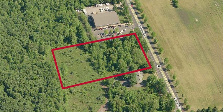
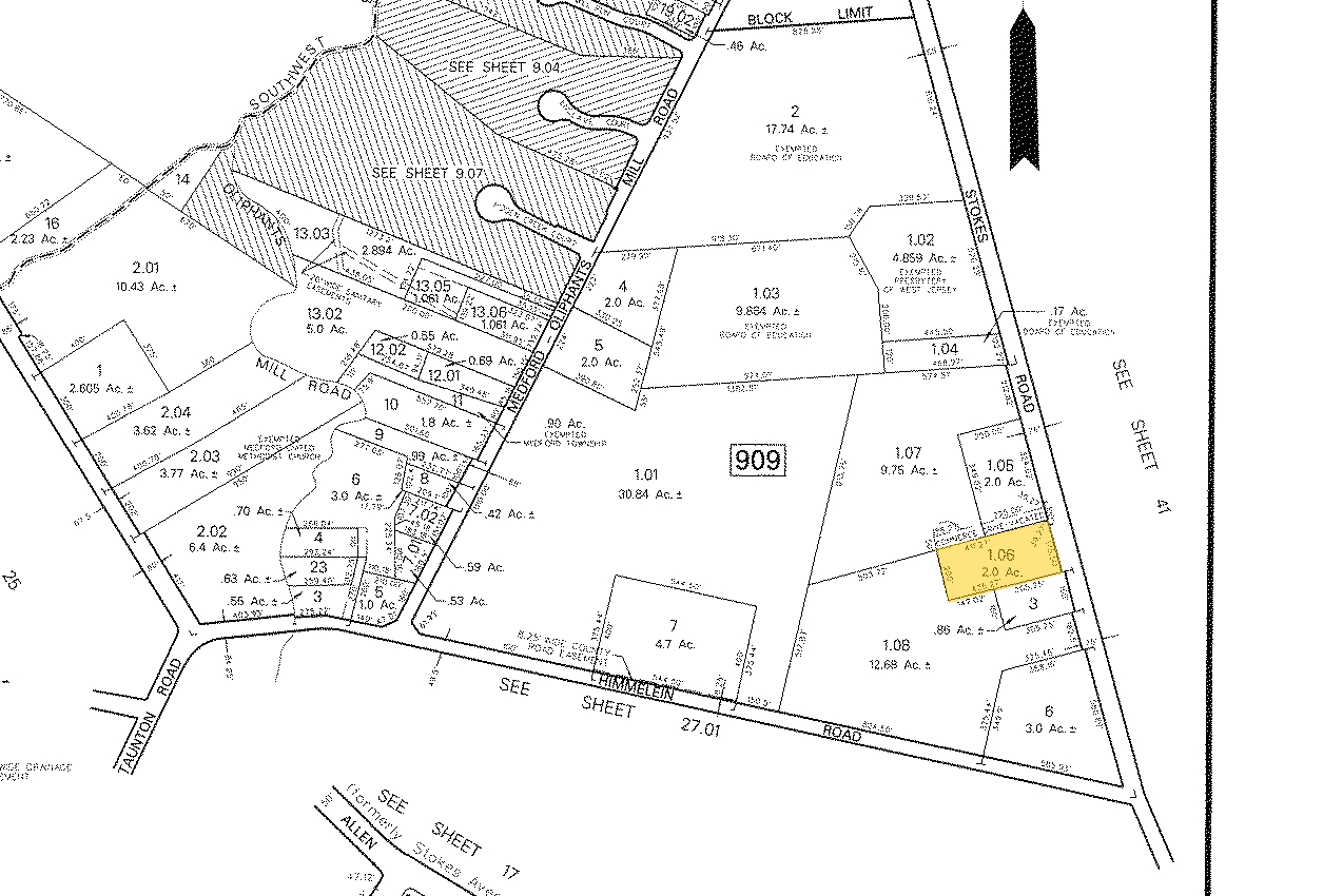
Property Record
328 Stokes Rd, Shamong, NJ 08088
NEARBY LISTINGS FOR SALE OR LEASE
Property Detail
328 Stokes Rd
Philadelphia-Camden-Wilmington, PA-NJ-DE-MD
APPROVED COMM LOT
20-00909-0000-00001-06
Burlington
Vacantlandnec
New Jersey
X
1.6
34005C0264F
2 AC
2023
South Burlington County
2024
Philadelphia
703700
DEMOGRAPHICS near 328 Stokes Rd
1 Mile
3 Mile
5 Mile
2024 Total Population
2,304
29,051
71,173
2029 Population
2,338
29,544
72,323
Pop Growth 2024-2029
+ 1.48%
+ 1.70%
+ 1.62%
Average Age
42
43
43
2024 Total Households
846
11,174
26,997
HH Growth 2024-2029
+ 1.65%
+ 1.78%
+ 1.67%
Median Household Inc
$130,105
$129,195
$129,135
Avg Household Size
2.70
2.50
2.60
2024 Avg HH Vehicles
2.00
2.00
2.00
Median Home Value
$364,308
$384,251
$379,207
Median Year Built
1974
1981
1984
Nearby Places
- Restaurants
- Banks
- Shops
- Fitness
- Groceries
PUBLIC TRANSPORTATION
AIRPORT
Philadelphia International
DRIVE
WALK
Distance
Philadelphia International
52 min
33.8 mi
Atlantic City International
DRIVE
WALK
Distance
Atlantic City International
63 min
34.4 mi
Freight Ports
Broadway Terminal - Pier 5
DRIVE
WALK
Distance
Broadway Terminal - Pier 5
36 min
23.2 mi
SALE & LEASE HISTORY
LISTING DATE
SALE/LEASE

Feb 03, 2023
For Sale
Nearby Properties
Address
Land Use
TOTAL SIZE
Lot Size
Zoning
Address
Land Use
TOTAL SIZE
Lot Size
Zoning
103.84 AC
PPE
Address
Land Use
TOTAL SIZE
Lot Size
Zoning
48.43 AC
Address
Land Use
TOTAL SIZE
Lot Size
Zoning
727.20 AC
PPE
Address
Land Use
TOTAL SIZE
Lot Size
Zoning
17.27 AC
PVR
Address
Land Use
TOTAL SIZE
Lot Size
Zoning
37.84 AC
RGC
Address
Land Use
TOTAL SIZE
Lot Size
Zoning
81.20 AC
RGD
Address
Land Use
TOTAL SIZE
Lot Size
Zoning
1,284 SF
20.03 AC
Address
Land Use
TOTAL SIZE
Lot Size
Zoning
8.95 AC
RG
Address
Land Use
TOTAL SIZE
Lot Size
Zoning
4.20 AC
LI
Address
Land Use
TOTAL SIZE
Lot Size
Zoning
40.08 AC
Address
Land Use
TOTAL SIZE
Lot Size
Zoning
25.48 AC
RD-I
Address
Land Use
TOTAL SIZE
Lot Size
Zoning
15.20 AC
Address
Land Use
TOTAL SIZE
Lot Size
Zoning
864 SF
4.54 AC
Address
Land Use
TOTAL SIZE
Lot Size
Zoning
4.30 AC
RGD2
Address
Land Use
TOTAL SIZE
Lot Size
Zoning
9,736 SF
4.43 AC
RGD
Address
Land Use
TOTAL SIZE
Lot Size
Zoning
1.27 AC
P
Address
Land Use
TOTAL SIZE
Lot Size
Zoning
14,176 SF
3 AC
PVI
Address
Land Use
TOTAL SIZE
Lot Size
Zoning
27,654 SF
3 AC
AP
Address
Land Use
TOTAL SIZE
Lot Size
Zoning
2,756 SF
2 AC
CC
Address
Land Use
TOTAL SIZE
Lot Size
Zoning
6,082 SF
6.92 AC
AP
Address
Land Use
TOTAL SIZE
Lot Size
Zoning
5,638 SF
1 AC
AP
Address
Land Use
TOTAL SIZE
Lot Size
Zoning
4,997 SF
21.87 AC
AP
Address
Land Use
TOTAL SIZE
Lot Size
Zoning
5,568 SF
3.06 AC
RGC
Address
Land Use
TOTAL SIZE
Lot Size
Zoning
17,792 SF
6.65 AC
RGC
Address
Land Use
TOTAL SIZE
Lot Size
Zoning
5,252 SF
0.73 AC
CC
Address
Land Use
TOTAL SIZE
Lot Size
Zoning
4,798 SF
1 AC
AP
Address
Land Use
TOTAL SIZE
Lot Size
Zoning
7.39 AC
Address
Land Use
TOTAL SIZE
Lot Size
Zoning
2 AC
PVR
Address
Land Use
TOTAL SIZE
Lot Size
Zoning
6 AC
PVC
Address
Land Use
TOTAL SIZE
Lot Size
Zoning
5,935 SF
1 AC
AP
The World's #1 Commercial Real Estate Marketplace
Connect with us
© 2025 CoStar Group
The information above has been obtained from sources believed reliable. While we do not doubt its accuracy we have not verified it and make no guarantee, warranty or representation about it. It is your responsibility to independently confirm its accuracy and completeness. Any projections, opinions, assumptions, or estimates used are for example only and do not represent the current or future performance of the property. The value of this transaction to you depends on tax and other factors which should be evaluated by your tax, financial, and legal advisors. You and your advisors should conduct a careful, independent investigation of the property to determine to your satisfaction the suitability of the property for your needs.